Dolly's Bike Blog

Musings about fun between my legs

Through Alpine

March 29: Fort Davis to Marathon, TX

At map meeting, Carol indicated that the route was not difficult today, so Donna and I decided to make an early stop at the Fort Davis Historical Site. Originally established in 1854, the fort protected settlers along the San Antonio-El Paso Road from Indians. After the Civil War, black infantry regiments were assigned to the Fort, sometimes called ‘Buffalo Soldiers’, as the Indians compared their hair to that of the buffalo.

20130329-202549.jpg

Fort Davis one of the best remaining examples of a frontier military post, including barracks, a commissary, a post hospital, lieutenants’ quarters and commanding officer’s quarters. The introductory movie was helpful in explaining the history of the area.

20130329-203144.jpg
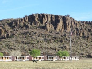
Looking at Officers’ Row

20130329-203239.jpgEnlisted Men’s Barracks

20130329-203345.jpgCommanding Officer’s Quarters

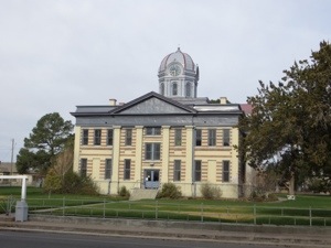
Donna and I spent close to an hour at the Fort before continuing on our route. We biked though the town of Fort Davis, past the local bank (closed for Good Friday) and the Jeff Davis County Courthouse.

20130329-203753.jpg

20130329-203818.jpg

We had to bike past the Chihuahuan Desert exhibit as there just aren’t enough hours in the day.

20130329-203944.jpg

As we entered the town of Alpine, I asked a local where to eat and he recommended Reata’s, just next door – a great selection. Not only was the food excellent, we enjoyed the great decor both inside and outside, inspired by the movie ‘Giant.’

20130329-204319.jpg

20130329-204349.jpg

20130329-204449.jpg

Alpine is the home of Sul Ross State University and also Hoss Cartright of Bonanza fame.

20130329-211738.jpg

20130329-211802.jpg

<a

Leaving town the mileage sign not only showed the distance to tonight’s location, but also to tomorrow’s destination.

20130329-211957.jpg

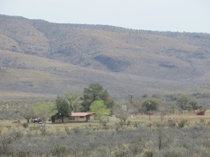
The road from Alpine to Marathon is quite straight, with occasional curves.

20130329-213847.jpg

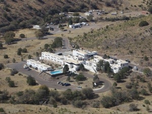
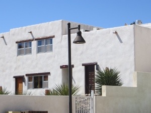
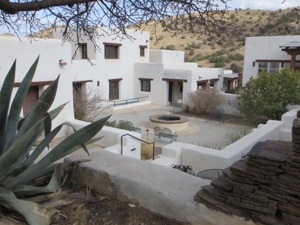
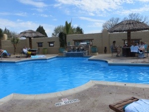
We are staying at the historic Gage Hotel tonight – our room is an adobe casita.

20130329-214132.jpg

Here are some photos of the hotel, courtyard and pool.

20130329-214616.jpg

20130329-214730.jpg

20130329-214824.jpg

20130329-215130.jpg

Linda, our cook, got to use a real kitchen tonight and we ate outside the Celaya House that is part of the hotel – yummy food as always, and a delightful outdoors.

20130329-220100.jpg

20130329-220308.jpg

My roommate tonight is Brenda Mamer from Wisconsin. She is a piano tuner back home and also likes to hike. She has a daughter studying linguistics in Germany and a son studying hydro geology in Buffalo, NY.

Total 62 miles today, average 11.8 mph.

Rest Day in Fort Davis

March 28:

After yesterday’s hard ride, it was easy to sleep in past 7 am. I did wake up in time to enjoy this sunrise.

20130328-153311.jpg

Beautiful early morning views of the Lodge and the nearby hills.

20130328-153416.jpg

20130328-153435.jpg

We tried to arrange transportation to the Observatory some 13 miles back uphill, but were unsuccessful. So we decided to hike the 1.7 mile Lodge Trail (got to keep my legs active). This is a photo of Helen and Brenda at the start of the trail.

20130328-153646.jpg

Up we hiked, with great views of the Lodge below.

20130328-153752.jpg

20130328-153832.jpg

We crested the ridge at 463 feet with a different view of the Lodge.

20130328-154019.jpg

Then downhill to the campground area.

20130328-154650.jpg

I dutifully cleaned my bike and also installed my ‘Texas chip seal bumper pads.’ (Thanks, Don, I hope they work.)

20130328-202804.jpg

Back at the Lodge, we met up with Luke, who had been our waiter last night, and had taken care of our laundry (facilities in Fort Davis are lacking).

20130328-154249.jpg

One of the Park employees gave a presentation on the Lodge, original sections built in 1934 by the Civilian Conservation Corps. The Lodge is all adobe block, each made from local soil, water, and straw.

20130328-154925.jpg

After dinner in the Black Bear Restaurant, I took a leisurely stroll, hoping to see the elusive javelinas (look like black hogs, in the rodent family). No luck but I did spy this ‘mountain lion’. (Do I need my eyes checked?)

20130328-202110.jpg

Some exercise, some laundry, lots of relaxation, a good day off!

Here are some extra photos of the Lodge:

20130328-202917.jpg

20130328-202942.jpg

20130328-203027.jpg

<a

Down, and Up to Fort Davis

March 27: Van Horn to Fort Davis, TX

Carol told us at map meeting that today’s route was long and hard – she wasn’t kidding.

Because of the distance, 89 miles, we got an early start, just as the sun was rising in Van Horn.

20130328-133716.jpg

The first 20 miles we rode on the shoulder of I-10, some downhill, not too much traffic and good surface. Our first sag stop was at an exit of the interstate. The trucks used it for support as well. Note the yummy arrangement of sag food and Moira checking our tires for wires and thorns. My average speed at this point was 14 mph.

20130328-134032.jpg

20130328-134052.jpg

20130328-134120.jpg

Back onto the interstate for another 18 miles, before exiting to head toward Fort Davis. It was then that we discovered Texas chip seal pavement and some climbing began.

20130328-134424.jpg

The winds on this road seemed to come from many directions, sometimes at our nose, other times across the bike, though nowhere near as strong as the previous 2 days. Note that the road is rising into the hills

20130328-143839.jpg

At mile 48, we found the van and trailer to provide lunch – no resources along this road. Average speed now down to 12.7 mph.

20130328-144005.jpg

It is fascinating to me to find ranch signs so far from the highway. I wonder about the isolation – how do they shop for food? Do they work each day?

20130328-144515.jpg

20130328-144556.jpg

Many of the cyclists decided to quit at lunch, knowing there were hard uphills ahead. The van was quite full. And there were many miles to go.

20130328-144723.jpg

20130328-144847.jpg

The climbing was hard, sometimes over 10%. When the computer read 3.0 mph, I took to walking. I was focused on the ride, not on the photos. Did stop to snap a picture of these cacti growing from the rocks.

20130328-145237.jpg

The top of the climb was at the Observatory, about 6,000 feet. I hope to take a tour on our rest day.

20130328-145400.jpg

Ten more miles to the Lodge, much of it downhill. Even with the chip seal, I was able to ride at over 30 mph for part of the descent. The scenery changed as we entered the Limpia Canyon.

20130328-145904.jpg

At last, a sign for the Davis Mountain State Park and the Indian Lodge, another mile back from the road.

20130328-150052.jpg

20130328-150148.jpg

I was so tired I walked the final climb to the Lodge entrance. Luckily, my room was just off the main parking lot. Though this is the ‘new’ section (built in the 60s), it has wonderfully historic furnishings.

20130328-150401.jpg

Dinner was in the Black Bear Restaurant, a yummy buffet, prepared by Chef Connie, shown here with our Chef Linda. Needless to say, I was exhausted, but triumphant in meeting the challenges of the day.

20130328-151520.jpg

My roommate is Carla Souza, from Brazil. She is one of the sag drivers, and also provides wonderful massages. She has one son who is a competitive sailor. I call her Bandita because she frequently wears a kerchief to protect from cold morning air or dust.

20130328-150838.jpg

Total 89 miles, ending average 10.3.
GPS readings indicated almost 5,000 feet of climb for the day.